Stones That Still Say Where You Are: A Weekend Field Guide to Boundary Markers
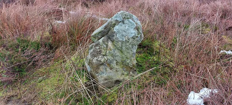
Photo: J Glew, CC BY-SA 2.0, via Wikimedia Commons
There is a stone at the edge of town that most people pass without seeing. It stands where the pavement gives way to a hedge, about knee-high, its face softened by rain. On one side are the letters 'P.B.' and, below them, '1843'. It is a parish boundary stone, and it has been doing its quiet job for longer than any of us have been alive. In 2026, when most of us navigate by phone, it is worth asking what these old markers still do — and how to read them on a weekend walk.
Why a lump of stone still matters in 2026
Boundary stones are civic furniture at its most frugal. They marked where one parish ended and another began, which once mattered for taxes, tithes, poor relief and the right to be buried in a particular churchyard. They were checked in rogationtide processions, when parishioners walked the bounds and beat them, sometimes literally, into memory. The stones are the surviving bookmarks of that older map.
Today they matter for a different reason. They are small, tangible pieces of local identity that do not need a visitor centre or a grant application. A neighbourhood plan can talk about character; a boundary stone shows it. They remind us that places are made by agreements, not just buildings.
First, learn the quiet vocabulary
Boundary markers are not all the same. On a stroll you are most likely to meet a handful of types.
-
Parish boundary stones. Often small, upright and inscribed with initials, a date or both. 'P.B.' may stand for parish boundary; other stones carry the initials of a parish or a landowner. Some are set into walls, some stand free.
-
Inscribed kerbstones and paving markers. Look down as well as up. Old kerbs sometimes carry letters, numbers or dates where a boundary crossed a road. They are easy to miss because they look like ordinary street furniture.
-
Milestones and turnpike markers. These are about distance rather than parish, but they belong to the same family of roadside memory. A milestone might name a town and a number of miles; a turnpike marker might carry the name of a trust.
-
Wall and gatepost stones. Initials cut into a gatepost or a boundary wall can mark an estate, a parish or a property. They are often the only dated thing left on a lane.
-
Replacement and modern markers. Some boundaries are still marked by newer stones or plaques, put in by councils or heritage groups. They are part of the same tradition, even if the lettering is sharper.
Where to look on a weekend stroll
Start at the edge. Boundaries often run along old lanes, field edges, streams, bridges and churchyard walls. Crossroads are good hunting grounds because parishes often met there. So are the places where a footpath meets a road, or where a wall changes height for no obvious reason.
Take an old map if you can. The Ordnance Survey's twenty-five-inch maps and tithe maps are gold for this, and many are available through local record offices or online. Look for 'B.S.' on the map, or a dotted line with initials. Then go and see whether the stone is still there.
And go gently. Many of these stones are on private land or beside busy roads. Stay on public rights of way, keep dogs close, and do not climb walls to get a better look. The best boundary walk is the one that leaves the boundary as it found it.
How to document a stone without damaging it
If you want to record what you find, think like a guest. Photograph the stone in context first, then close up. Include something for scale, such as a coin or a notebook, but do not balance it on fragile stone. Note the grid reference or a What3Words location. Write down the inscription exactly, including any damage.
Do not scrub the stone, chalk it, paint it or take a rubbing. Soft stone loses detail every time someone tries to help. Do not move it, even if it has fallen. Report it to the local heritage society or the council's conservation officer if it is damaged or at risk. Share your photos with a local history group rather than posting a precise location of a fragile marker on a busy public page.
A gentle route for a Saturday
Pick a loop of two or three miles around the edge of town. Start at the parish church, follow the oldest lane out, and look for the places where the wall changes, the hedge thickens or the road bends. Take a notebook, a phone, an OS map and a flask. Wear something you do not mind getting muddy. End at a café and compare notes.
If you find a stone, give it a moment. Read the initials. Check the date. Ask what agreement it was marking. You will not solve the whole history of the parish in an afternoon, but you will have added one small thing to the map in your head.
The stone at the edge of town
Back on the edge of town, the stone with 'P.B. 1843' is still there. It is not beautiful, exactly. It is weathered and slightly crooked. But it says where you are, and it says that someone cared enough to mark it. In 2026, that is worth a nod.